The History of the Commons

The Vale Commons are under the control and supervision of the Vale Commons Council under the 1932 Ordinance of the Royal Court.
The Council is composed of five members of the Habitànts of the Clos du Valle, two of which must be Douzeniers and are all elected by the Habitànts. Habitànt means a person who has resided in the Clos du Valle for a period of not less than nine months. The Clos du Valle is the area of Guernsey north of the Braye du Valle.
In general the function of the Council is to regulate and supervise the use of the commons not only as a place for the exercise of the Habitànts grazing rights, the right to graze animals on the commons but also as place of public resort and recreation.
Under the 1932 Ordinance it is an offence to damage the turf, without the permission of the Council and in order to uphold this law police special constables and rangers have been appointed to patrol the commons to ensure, amongst other things, that vehicles do not drive or park on the grass, horses only walk, metal detector enthusiasts do not dig, dog walkers pick up after there animals and model aircraft are not flown over the commons.
Commons Ownership
The Vale commons consist of 737 vergees (300 acres) stretching from the Vale Church in the West to Fort Doyle on the East coast. This area makes up approximately fifty percent of the recreational land available to the public in the Island, the rest being managed by the States.
Although referred to as a common most of it is privately owned having been sold by the English Crown in 1583 to a Stephen Harrington, who in turn sold it and it was eventually divided and subdivided and sold to many others. One of the provisions of any sale is that of the Habitànts right to graze their animals. Only the Crown can rescind that right.
To this day the habitànts of the Clos du Valle may exercise their rights to put animals on the common. At one time in the 1980’s there were so many animals on the common that it was difficult to find enough grass for them to graze on and the Commons Council considered closing parts of the common to animals to enable the grass to recover. The only time cows have not been permitted on the common was during the Foot and Mouth outbreak in England in 2001, the cows were removed as a precaution.
A familiar sight on the common for many years after the second world war was a herd of Golden Guernsey goats owned and bred by Miss Milbourne who lived at the Doyle Hill, the site of the old barracks.
Lost Commons
To the south of L’Ancresse common were the commons of Les Landes and Rocque au Coucou, (originally spelt Cucu) and until 1864 these were subject to grazing rights. This particular part of the Vale commons had a long and tortuous history before it was finally sold off in lots and eventually developed and urbanised.
An Order in Council was made on July 28th. 1864 authorising the enclosure and sale of Les Landes and Rocque au Coucou commons. Half the profit from the sale was used to build two schools and the other half for the relief of the poor of the parish.
ANCIENT HISTORY
Megalithic tombs and ancient sites
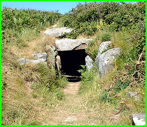 La Varde
Some of the megalithic tombs found on the Vale commons are Les Fouaillages, La Mare ès Mauves c2000 BC and another similar cist some 80 metres to the north east, La Varde c3500 BC, La Platte Mare c2500 BC and La Hougue ès Vanneaux. A cist-in-circle is known to be under a visible hump on the triangle of common near the Passeur road, another is hidden under earth between the road to L’Ancresse east and the Doyle Hill while a third is situated north of Les Clotures road between the Rocque Balan and the Chouet cross-roads. There is also a Christianised menhir between number 7 tower and La Mare ès Mauves.
These megalithic tombs were probably deserted around 2000 BC when Eastern Europeans invaded and plundered the Island forcing many of the inhabitants to leave or be slaughtered.
The largest Megalithic tomb still to be found on L’Ancresse common is La Varde, c3500 BC.
It was excavated in 1811 by the botanist Joshua Gosselin when it was discovered by soldiers at the beginning of the 19th. century while building a defensive position (a redout) as part of Lt. Governor Sir John Doyle’s fortification of the Island. After removing about four feet of sand the soldiers found the tomb which had a large stone across the entrance and steps leading down into the chamber which allegedly had a pebble floor. By the time Joshua Gosselin was able to inspect it the steps and pebble floor had been removed. One of the artefacts found inside the tomb was a fish bone disc about nine inches in diameter which the soldiers gave to Sir John Doyle, while the young twenty three year old Frederick Corbin Lukis took a skull.
La Rocque Balan
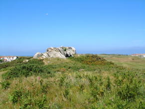
Believed to date back to the Bronze age, at the top of the Rocque Balan rock, there are three hollows carved into the flat surface.
The purpose of the three cups at the top have been attributed to sacrificial rituals and were possibly used to hold blood. At Midsummer on the eve of St. John’s day, locals used to dance on the top of the Rocque Balan singing “J’irons tous à la St. Jean, dànsaïr sus la Rocque Balan” (On St. John’s eve we will all go, To dance on the top of the Rocque Balan)
It has also been suggested that the Rocque Ballan area was where there was a balancing stone for the Prior of St. Michel to weigh the goods of his tenants
Pre-Martello Towers
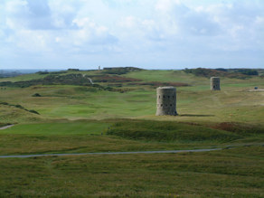
Fifteen pre-Martello towers, although they are commonly called Martello towers, were ordered to be built on the 17th. July 1778 on behalf of and at the expense of the Crown six of which, numbers 4 to 9, are on the north perimeter of the common.
The reason they were constructed was as a result of a request by the Governor of Jersey, General Seymore Conway, who was convinced the French would soon invade the Channel Islands. At a cost of £156 per tower their construction started on the 31st. August 1778, all fifteen were completed by March 1779 and were the first to be built in the British Isles. The distance of 500 yards between the towers was calculated to catch the enemy in a cross-fire.
Devils Footprint
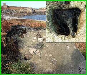
To the south of the coastal path between Fort le Marchant and Fort Doyle is a rock with the shape of a cloven hoof imprinted in it. Legend has it that the Devil would leap across the Islands leaving his footprints as he went.
Fairy Well
Just to the north of the old Câtelain quarry is the Fairy well, at this time no more that a bucket size depression in the ground this little well is marked on the 1900 map.
Early Settlers
The early inhabitants of the Clos du Valle, dating back some 7000 years or more, were middle stone age Mesolithic nomads from the Middle East who hunted and fished to survive, evidence of their occupation was found at Les Fouaillages.
In 1979 excavations at Les Fouaillages, near the fifth golf green, revealed that this area had supported residents for many years. The tomb dated back to c4500 BC and is believed to be the earliest of its kind in Europe found so far.
About 1000 years later new stone age Neolithic farmers settled here, remains of their constructions have also been found on the common near Les Fouaillages.
Nearly 3000 years later the Bronze Age and then Iron Age people inhabited and cultivated the same area living off the land and sea.
Many of the settlements were lost when the sea level rose in the first century. Gradually sand blew over the area covering the land that had once sustained life leaving a soil structure similar to dry heathland peat. The top few centimetres of most of the common is now comprised of part-rotted root and stem particles mixed with sand and shell grains.
FOLK-LORE
La Rocque qui Sonne
The story of La Rocque qui Sonne (the ringing stone) places a dolmen on the edge of L’Ancresse common in the grounds now occupied by the Vale school. An old tale about Mr. Hocart who used some of the stone to build a house nearby tells of dire consequences that befell upon the poor man after being warned by the locals not to desecrate the tomb. Apart from the fate of Mr. Hocart this story illustrates just how far the commons stretched to the south and portrays a typical example of a truly stubborn ‘Guernsey donkey’.
The people of the Vale parish believed the Rocque qui Sonne cist held supernatural powers and advised Mr. Hocart not to use it to build his house but no amount of persuasion would shift him from breaking up part of the tomb and incorporating it into the fabric of his new home.
When completed two of his servants were sent to clean the place before the family moved in and while they worked the house caught fire killing them both. The locals believed the curse of the tomb was at work but if Hocart thought that was the end of it he was wrong. Stone he had not used was shipped to England on two boats he co-owned but the vessels never reached their destination, vanishing without a trace. Perhaps Hocart thought he could escape the curse because he decided to leave Guernsey and went to live in Alderney but the curse followed with a vengeance. No sooner had he set up in his new home than another fire burnt it to the ground. The poor man decided to return to Guernsey and boarded a ship bound for his home Island, this is when the curse finally released him as the boat’s rigging fell on his head and killed him!
FORTIFICATIONS
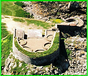
Fort l’Angle later named Fort le Marchant.
In the 1680 Legge report for Charles II, Col. Legge refers to Fort l’Angle as needing three 12 pounder guns mounted on ship’s carriages to cover the approach to the harbour but when this most northerly point of the Island was initially fortified is unknown.
Used as a Watch House in the middle of the eighteenth century it was manned by soldiers of the Militia’s Town Regiment. In 1796 the States decided to enlarge the fort giving the task to the Lt. Bailiff Eleazar le Marchant and it was re-named Fort le Marchant in 1805.
Supplies for the fort were carried by horse and cart including water, whereas most properties in those days had at least one well it appears the fort did not. At a cost of two shillings and six pence (twelve and a half new pence) a barrel this essential commodity was supplied and carted to the soldiers posted at the fort by Job Henry who lived on the edge of the common.
During the first world war it was used as a look-out point and during the second world war the Germans made good use of it in their defence against the Allies. In 1970 the States deemed the outer stone and cement structure to be dangerous and demolished it, leaving the inner building that was once the Watch House and which still stands today.
In Marie De Garis’ book ‘Folklore of Guernsey’ there is a little anecdote concerning a haunting at Fort l’Angle. The tale goes that at times a soldier can be seen, with drawn sword, to frighten anyone who approaches the area!
Fort Doyle
( adjacent to La Lande common )
Built in 1803 by the States of Guernsey it was originally called Doyle Battery after the newly appointed Lt. Governor Major General Sir John Doyle. This fort was constructed in anticipation of a possible invasion from France
In 1855 the fort was enlarged incorporating a drawbridge and with the threat of an attack from the French diminishing this little defence post was put to other use.
Used as a back up signal station should the Platte Fougère lighthouse go out of action, it was also used as a store for the lighthouse which was built in 1909 and was the first off-shore, concrete, remotely controlled lighthouse to be built in the British Isles.
Doyle Barracks
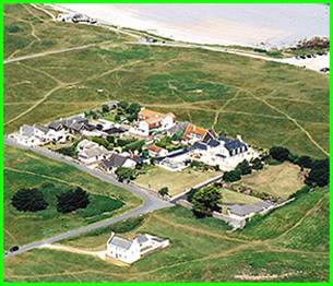
Built on a flat topped hill, near L’Ancresse bus terminus the area called Hautville is where the Doyle barracks were built around 1804. Consisting of wooden quarters for 14 officers, 312 men and six horses with one hospital for 30 patients. The object being in time of war to guard against being surprised by any sudden landing of the enemy in the north.
When the hostilities between England and France were finally over in 1815 French officers were held in these barracks and so for a while the Doyle barracks became a prisoner of war camp before being sold to Thomas and Jean Henry in 1817.
German Fortifications
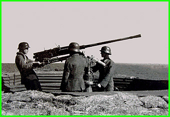
During the second word war the German occupying forces made a considerable impression on the Islands landscape, not least of all on the common. The defence of this part of the Island entailed the construction of bunkers, a variety of emplacements for flak guns, machine guns, search lights, radar, barracks and an anti-tank sea wall. The common was also covered with poles that had wires stretched between them to deter gliders and paratroopers from landing, it must have looked like a demented giants cats-cradle. Thousands of yards of barbed wire encircled areas out of bounds to the local population, mine fields were laid and a railway line built across nearly the entire width of the common for the transportation of stone and sand, during the time it took to build the fortifications and a great deal of sand was dug out of the common leaving unnatural craters.
After the Liberation before the trenches were filled in and all the bunkers cleared of German equipment locals helped themselves to a variety of ‘souvenirs’. Helmets, small arms and periscopes were just a few of the reminders of the occupation that became spoils of war and those who were in the Island during the occupation recount stories of the unusual ‘toys’ they played with as children. Dismantling periscopes for the lenses and using them on a sunny day to set fire to little piles of dry grass or to burn shapes in paper. Utilising the helmets to make miniature ponds for the tadpoles caught in one of the ponds on the common kept many a youngster amused for hours. Hundreds of flares were left in the bunkers which one group of young local lads put to no good use and sent the police on a merry chase when they let the flares off then ran along the trenches out of sight to another location to let more off. Luckily for them the police never caught them but a year or so previously they had nearly been shot when caught ormering at the Fontenelle, a German machine gunner spotted them and bullets flew around their heads as they scurried off the beach.
Housing Russian soldiers
During the winter of 1799 Russian troops were billeted on L’Ancresse common after being evacuated from Holland. They had fought alongside the British and were unable to return to Russia until the ice had broken in the Baltic. Because of the terms of the 1698 Bill of Rights they were debarred from entering the United Kingdom resulting in 6000 soldiers being sent to Guernsey. Many of the unfortunate soldiers contracted a fever in the Dutch marshes and several hundred died during their stay in the Island.
ACTIVITIES ON THE COMMONS
Shooting
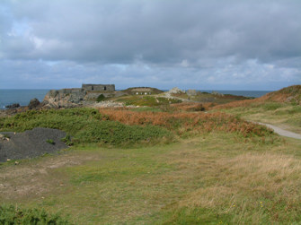
A variety of different shooting disciplines have utilised the common over the years from the Guernsey Militia in the 17th. century (with the Vale force consisting of 114 men and boys mustered on August 27th. 1621) to the rifle clubs, police and rabbit shooters of today.
Before the range at Fort Le Marchant was built in 1955 at least three rifle ranges were built on the common at different times. The present full bore range at Fort le Marchant was constructed in 1955 after the Military Service Committee applied to the States in February that year for funds to provide a rifle range.
At the present time the range accommodates the Guernsey Rifle Club, the Elizabeth College Combined Cadet Force and the Annemarie Shooting Club.The Guernsey police constructed a range to the north of the car park at the Câtelain with the habitànt’s permission and started to use it in 1996 to train their armed response unit.
Apart from these organisations the common is the hunting ground for rabbit shooters from October 1st until the last day of February and is available for military manoeuvres including the local Sea Cadet Corps and the Guernsey Army Cadet Force with the permission of the Lt. Governor of Guernsey and the Commons Council.
Playing Fields
In 1937 an informal agreement was drawn up between the Vale Douzaine and the Vale Commons Council for an area on Le Jaonnet common to be designated as the parish recreation grounds. Today those playing fields consist of two football pitches and are still under the management of the Vale Constables and Douzaine.
Model aircraft and drones
The Guernsey Model Aircraft Club started using an area of common along side the 6th. fairway as a model aerodrome in 1967 much to the annoyance of the golfers and residents in the nearby vicinity. As a result of complaints regarding safety, after a few ‘close shaves’ when aircraft crashed near members of the public, the Tourist Committee requested that flying be prohibited over the golf course and the police wrote expressing great concern for the safety of the public.
In 1973 the States voted to ban all model aircraft and drones from flying over L’Ancresse common. The new Ordinance prohibiting model aircraft and drones came into effect on April 25th. 1974 and a new site for the Model Aircraft Club was found on States land at Chouet.
Children’s Playground
Vale Douzaine asked the Commons Council for an area of common to be made into a children’s playground which the Douzaine would equip and maintain, as a result of which the popular playground at Les Amarreurs was established in 1976.
Sports
Cross country runs held by schools and clubs and motorcycle and car club trials are held in designated areas.
Civilian horse racing was first established on L’Ancresse common in 1828 with the Guernsey Young Farmers Race Club, the Guernsey Race Club and the Guernsey Riding and Hunt Club having all made good use of the common over the years. Recreational horse riders are only permitted to walk their horses.
During the second world war German officers exercised their horses on a cross-country course designed to avoid all the mines and barbed wire.
Recreational cycling on the coastal paths only was sanctioned by the habitànts in 2002 with pedestrians having priority and with a speed limit of 10mph.
POLICING THE COMMONS
Special Constables & Rangers
In 1935 the first Special Constable was appointed by the Commons Council to oversee the golf links only; then in 1937 another constable was appointed to cover the whole of the common due to a problem with vehicles driving over it.
Today there are ten Special Constables, some of whom are also Rangers.
These unpaid volunteers ensure the common is not abused, preferring initially to persuade transgressors to respect the common rather than taking immediate legal action.
COMMON HABITAT
There are several natural habitats on the commons, some especially rare in Guernsey making them very important for biodiversity. The dry grassland that covers most of the commons is rich in plant and insect species which are unique to the commons and not found anywhere else in the Island, some are not even found in the UK
The wetlands at La Grève, La Hougue Patris and to the west of the L’Ancresse road support wild orchids, while in other areas there is a large variety of flora and fauna. Rare species such as Adders Tongue, Louse Wort, Bog Pimpernel and Guernsey Centaury grow near the pond just north of the Mont Cuet road, this pond is the only site in Europe to sustain the crustacean Cypris Bispinosa.
In the hollow opposite the Pembroke slip-way Wild Asparagus and Dwarf Millet can be found.
A little further north near the Platon Battery, Earth Tongues and Sea Holly survive on the sand dunes and at a number of other locations a variety of plant species appear when conditions allow such as Alderney Geranium, Land Quillwort, Hedgrow Geranium, Long Leaf, Deptford Pink, Orange Bird’s Foot and Yellow Centaury.
Only five ponds remain which at one time were used by farmers to water their animals, sadly this practice has died out as the number of animals on the commons has diminished drastically over years. Great care has to be taken when cleaning these ponds, the bottoms of which are lined with blue clay, in order not to disturb the rare flora and fauna.
DEVELOPMENTS ON L’ANCRESSE COMMON
Railway
In 1845 plans were in the pipeline for a railway to run from Pembroke to Perelle via St. Sampson, St. Peter Port, Câtel, St. Saviour and King’s Mills. This scheme also incorporated a deep water harbour in L’Ancresse bay.
Airport on common
In 1931 the States of Guernsey investigated the possibility of putting an airport on Le Jaonnet common. The area involved was the entire stretch of common between Les Amarreurs road and Mont Cuet road and possibly beyond, with four runways.
States Houses
Another development that never materialised was the building of States Houses on the triangle of common at La Garenne.
The Millennium Stone
To mark the year 2000 the Vale Douzaine decided, on a proposition made by Douzenier Brian De Jersey, to erect a menir type stone on the hill near La Varde tomb on L’Ancresse common. Standing approximately 7ft. high and weighing more than 25 tonnes it was quite a feat to transport the stone from L’Ancresse beach to its resting place on the common.
On July 12th. 2001 Queen Elizabeth II unveiled the stone in front of hundreds of Islanders.
CONCLUSION
The fact that the commons have been managed by habitànts of the Clos du Valle since 1823 has contributed in no small way to the preservation of the area. The Vale Commons Council members of today live either on the edge of the commons or just a stone’s throw away, as did their predecessors and those members of the committee set up in 1875 and the constables before then.
The history of the commons which has been passed down through the families of the parish has furnished each generation with the knowledge required to ensure it’s preservation, something the habitànts of the Clos du Valle understand only too well which is why any perceived interference or attempt to take over the management of the commons by an outside body is robustly resisted. This stand by the Council and habitànts is occasionally seen as being intransigent, not willing to move with the times, but in effect this is why the commons are still there.
While modern day demands continue to change large areas of the Island’s facade the rich history of the commons make them quite unique and they are vigorously guarded by the Vale Commons Council and the habitànts of the Clos du Valle who endeavour to keep this unspoilt part of the Guernsey much like it might have been many years ago. It is for future generations to protect the commons that remain but to do so they need to be aware of the history attached to this wild and beautiful part of Guernsey.
